
Mount Tammany
If you have traveled along Route 80 between New Jersey and Pennsylvania, you have seen Mount Tammany but may not have known it's name. It is the huge chunk of rock on the New Jersey side of the Delaware Water Gap; Mount Minsi is on the Pennsylvania side. The Delaware Water Gap is a true treasure and a place that I will never cease to be in awe of. In the past I have twice tried hiking to the summit of Mount Tammany only to be turned away. If memory serves me the first time was in 1985 - this was to be an overnight camping trip with a friend but shortly after we began our trek up the Red Dot Trail he became ill and we had to turn back. I returned a few years later (1988? 1989?) to attempt a solo camp-out only to injure my knee, again on the Red Dot Trail, and needing someone to help me back to the car. I vowed that, one day, I would make it to the top. I finally made it last Friday and this post is all about the adventure. There are a few routes to the top of the mountain but the most popular would be the Red Dot Trail up and the Blue Blaze Trail on the way down. The last half-mile follows Dunnfield Creek trail. This is the recommended route since the Red Dot Trail can be very difficult to navigate on the way down. I was accompanied by my son, Joey, on this trip and I don't think I would have been successful without him.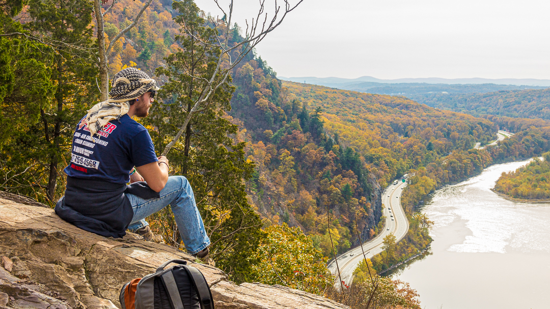

The Trails
The Red Dot Trail
The Red Dot Trail is a very challenging trail with steep climbs and more than a few rock scrambles. It is about 1.5 miles to the summit of Mount Tammany along this route with a change in elevation of more than 1,200 feet. The trail is almost entirely rock once you get past the stairs at the beginning of the trail. Fortunately, it is solid rock and it doesn't move when you step on it.The Blue Blaze Trail
The Blue Blaze Trail is 1.7 miles, again, with an elevation change of more than 1,200 feet. The trail isn't as challenging as the Red Dot but it has it's own challenges. The trail is not as rocky as the Red Dot but a lot of the rocks are loose and there is a good layer of leaves to go along with them. This makes the footing a bit tricky at times when a rock moves under foot or you step on some leaves onto the point of a rock. You also have to work hard to maintain control because gravity wants to get you to the bottom far faster than is safe.Dunnfield Creek Trail
The Dunnfield Creek Trail connects the Blue Blaze Trail to the parking lot. I had hiked this trail once before, in November 2018, and wrote about it for my other blog. If you want to learn more about the trail, check out A Brief Hike Along the Appalachian Trail
The Hike
The Ascent - Red Dot Trail
When we arrived at the parking lot it was almost 3/4 full and it was only a bit past 11:00 in the morning. I was very surprised to find that many people on a Friday morning. I stopped along the way to pick up some granola bars and snack crackers to eat along the way so we stashed them in our packs, checked to be sure we had enough Propel1 and were on the trail by 11:20 AM. Earlier I mentioned that I don't think I would have been successful were my son not with me and I meant it. To backtrack a little, I went hiking at Turkey Swamp Park the day before and my knees were a bit sore from that hike; I probably would have changed my destination to a less challenging one if I were going alone. We had planned this hike for a couple weeks and I wasn't going to back out now. The beginning of the trail is a steep series of steps created with, what appear to be, railroad ties. I had climbed about 50 or 60 yards (I'm guessing) when my legs got a bit tired. This was, in part, due to the soreness of my knees but also the weight of the pack and the fact that I am not as fit as I thought I was. It was about 10 minutes into the hike that I began to wonder how I was ever going to get back to the car but was determined not to quit this time - we were getting to the top! I took the lead, cautiously picking a path along the rocks while keeping an eye out for snakes🐍. Yes, there are snakes in the woods, and bears🐻, more about that later. The trail was steep but the ground solid so there was no fear of sliding. To my surprise, there was a good amount of traffic going down the trail; when someone approached I stepped to the side, letting them by while also taking a brief break. It wasn't too long before we can to a spot that I thought might be the clincher; a solid wall of rock, about five or six feet high and no way to hike around it. I looked at Joey and then back at the rock. We found some ridges in the rock that we could step on and carefully made our way to the top of it. The rest of the way to the top was just finding the easiest route thru the rocks. I had a few criteria for the route - minimal step up height was primary but I was also staying away from anything that looked like a good place for snakes. We finally saw a clearing and when we stepped out of the woods the view was breathtaking. This was, I thought, the peak; the hardest part of the journey is behind us. We took our packs off, had a drink and I took out my camera and tripod. This was also a good time to eat a bit. The image, Joey Enjoying the View, was captured at this spot. I also shot, The Delaware River, at this location. While I was looking for compositions, Joey chatted with a young couple sitting on a nearby rock. They said that, shortly before our arrival, a Cessna flew thru the valley at just about eye level - about 1,400 feet. We were there for about 15 or 20 minutes before I grabbed a quick picture of us with my phone and we got back on the trail for our descent, or so we thought. We were wrong.... We had about another 20 minutes or so before reaching the summit and another spectacular view of the Gap.

The Descent - Blue Blaze Trail
We rested at the summit for a short time before reaching the Blue Blaze Trail and the way down. As I mentioned earlier, going down turned out to be almost as challenging as going up due to loose rocks, leaves and gravity. It was also due, in no small part, to my physical condition and the fact that my legs were turning into rubber.... There are no grand vistas to take in on the way down but you are surrounded by thickening forest and it's natural beauty. As Lord Byron once wrote, "There is pleasure in the pathless woods...." and while we were not in a "pathless woods" I can't think of many places more pleasureful and peaceful. We stopped more often on the way down for a couple of reasons, not the least of which was to give my legs a bit of a rest. We got passed by many people and while I admired their tirelessness I also thought they were missing out on the experience. I know that many make this hike a part of their routine and have probably hiked it as many times as I have the woods in my backyard but there is always something new to be experienced if you are willing to open yourself to your surroundings. I hope a hike in the woods never gets to be "routine" or simply exercise; I want to experience every hike as though it was my first time. I didn't take my camera out of the bag on our way down, woodland photography is an art all it's own and not one that I am particularly skilled at. I was also anxious to get to Dunnfield Creek and the waterfall. There were more than a few times when I saw a bend in the trail and thought we would see the footbridge over Dunnfield Creek when we got to it, only to learn that I was mistaken. We had come to a few of these bends before Joey stopped and said that he heard water. That's it!
Dunnfield Creek Trail
We finally made it to Dunnfield Creek and we settled down on a bench overlooking the falls and creek below. The water level was much lower than when I was there last (see A Brief Hike Along the Appalachian Trail) but it was truly a spectacular sight. It was at this point I grew frustrated with myself because I simply didn't have the energy to properly shoot the scene. I grabbed a couple images with my phone before we headed over the bridge and down the trail to the parking lot. It is a bit over a half-mile to the Dunnfield Creek trail head from here, relatively flat and easy going. There are some rocks and roots to contend with but the hike is one that just about anyone could handle without stress. It may also be the most beautiful section of the hike. The creek is in view the entire way and there are countless small waterfalls and rapids but this is just part of the beauty. The area surrounding the creek is full of color from moss growing on rocks, the fallen leaves and other vegetation. The downside, from a photography standpoint, is that getting down to the water is no easy feat and, at times, not even a possibility. The last time I was there I found an outcropping of rocks that afforded a great view but we must have passed it before I thought to check it out again. We did find another area with a view, a somewhat more treacherous spot to get to but worthwhile. I made a note to stop there when I next hike the trail.
The End
After nearly four (4) hours of hiking (and time spent resting....) we reached the Dunnfield Creek trail head and parking lot. We made it! Well, we almost made it. When we got to the parking lot I realized that the smart hikers were parked in this lot but we still had a bit of hiking left because we parked in the Red Dot Trail lot. It isn't a great distance but it would have been wiser to park at Dunnfield. There is a sign signaling the Red Dot Trail trail head, accompanied by a sign to beware of the two (2) types of venomous snakes inhabiting the area. Immediately beyond the signs were lay the trail with a series of steps leading up - I was on level ground and didn't think another ascent, no matter how short, was going to go well so we opted for a slightly longer walk along the road. We finally reached the parking lot but there was no sign of my car! I had been worrying about getting back to find the rear window broken out because I accidentally left a camera out - Joey was going to use my spare camera but I forgot to give it to him. I didn't realize this until we were to far along the trail to go back. While I was prepared to see a break-in, I wasn't prepared to find the car had been stolen! We both looked at each other, that was when I realized he thought the car was gone too. It turns out it was still there, a large pickup truck was parked next to us and completely blocked the car from our view. The camera was also right where I left it. I was exhausted! Joey offered to drive but, having seen Disturbia more times than I can count, I told him I was okay to drive. (If you don't get the reference, I suggest watching the movie - a modern take on Rear Window.) We headed back along Rt 80 towards our reward - The After! I've written of The After before, a childhood favorite restaurant in Flanders that we introduced the kids to when my daughter started school in Pennsylvania. We don't get there as much since she graduated so it is regarded as a special treat. We had our dinner, I got my ice cream and then we headed for home. We arrived home some time around 7:00 PM, having left at a little past 9:00 AM, exhausted and filled with memories that will last a lifetime.Bears 🐻 and Snakes 🐍
I mentioned bears and snakes earlier in the story and wanted to touch upon the subject before I finish. It is important to understand that this is bear country and the possibility of an encounter is ever-present. I wasn't too concerned on this trip due to the large number of people on the trail, the bears nature is to avoid human contact so it would have been very unusual for one to be anywhere in the area. The mountain is also home to New Jersey's only two (2) venomous snakes - the timber rattlesnake and copperhead. I have a friend who frequents Mount Tammany and just this year he has encountered rattlesnakes more than once. They love to get into crevices of rocks and so you should never put a hand or foot somewhere that you cannot see into. I would suggest reading about snakes and bears prior to visiting this area, know what to look for and what to do if you have an encounter - the life you safe may be your own. I hope you have enjoyed reading about our adventure - I know I enjoyed reliving it while writing this and will relive the adventure, treasuring the memories, until my last breath.Notes:
1 Propel is a zero-calorie sports drink and comes in a variety of flavors. If you're curious, we had Mandarin Orange and Black Cherry on this trip. 😉
All photos are copyright Joseph S. Valencia All Rights Reserved They may not be used in any way without express written permission of the photographer. If you wish to use any of the photos you may contact the photographer at valencia32photo@gmail.com


No comments:
Post a Comment